GeoDjango widgets
django-floppyforms provides fields and rich widgets for easy manipulation of GEOS geometry fields. All geometry types are supported thanks to OpenLayers and a custom WKT parser/serializer implementing some Django-specific tweaks.
Note
Since GeoDjango doesn’t provide any rich widget out of the box (except for the admin), the API described here is not trying to look like any existing API in GeoDjango.
The geographic fields and widgets are provided under the
floppyforms.gis namespace.
Setting up
To make sure you’re ready to use the geographic widgets, follow the
installation instructions for GeoDjango closely. You need to have
'django.contrib.gis' in your INSTALLED_APPS setting.
Next, you need to serve the javascript library provided by django-floppyforms
(located in floppyforms/static/floppyforms/js/MapWidget.js).
You might want to use django.contrib.staticfiles, so that the javascript
library will be picked up automatically and gets served by the development
server. Just make sure you run manage.py collectstatic once you deploy
your project.
Widget types
django-floppyforms provides base widgets and geometry-specific widgets:
- base widgets are in charge of rendering a map from a specific map provider (Metacarta, Google Maps, OpenStreetMap…). They are not aware of the type of geometry, they need to be complemented by geometry-specific widgets.
- geometry-specific widgets are here to make base widgets aware of the type of geometry to edit: is the geometry a point? A polygon? A collection? Geometry-specific widgets provides these information so that the corresponding controls are activated.
To get a fully working geometry widget, you need to define a class that inherits from a base widget (to specify the map provider) and a geometry-specific widget (to specify the type of geometry you want to create). Here is a quick example:
import floppyforms as forms

class PointWidget(forms.gis.PointWidget, forms.gis.BaseOsmWidget):
    pass
Here BaseOsmWidget is the base widget (i.e. I want to see an
OpenStreetMap) and PointWidget is the geometry-specific widget (i.e. I
want to draw a point on the map).
Base Widgets
The following base widgets are provided:
BaseMetacartaWidget: this base widget renders a map using the Vector Level 0 map from Metacarta.
BaseOsmWidget: this base widget renders a map using OpenStreetMap.
BaseGMapWidget: this base widget renders a map using the Google Maps API. It uses the v3 javascript API and requires an API Key (which can be obtained at Google Developers). Subclasses must set the attributegoogle_maps_api_key, otherwise the map will fail to load.
import floppyforms as forms

class PointWidget(forms.gis.PointWidget, forms.gis.BaseGMapWidget):
    google_maps_api_key = 'YOUR-GOOGLE-MAPS-API-KEY-HERE'
Geometry-specific widgets
For each geographic model field, here are the corresponding form fields and form widgets provided by django-floppyforms:
| GeoDjango model field | Floppyforms form field | Floppyforms form widget |
|---|---|---|
| PointField | PointField | PointWidget |
| MultiPointField | MultiPointField | MultiPointWidget |
| LineStringField | LineStringField | LineStringWidget |
| MultiLineStringField | MultiLineStringField | MultiLineStringWidget |
| PolygonField | PolygonField | PolygonWidget |
| MultiPolygonField | MultiPolygonField | MultiPolygonWidget |
| GeometryField | GeometryField | GeometryWidget |
| GeometryCollectionField | GeometryCollectionField | GeometryCollectionWidget |
Each form field has a default form widget, using the corresponding geometry-specific widget and the Metacarta base widget. A form defined using nothing more than floppyforms fields will be displayed using the Metacarta WMS map service. For instance:
# forms.py
import floppyforms as forms

class GeoForm(forms.Form):
    point = forms.gis.PointField()
{# template.html #}
<html>
  <head>
    {{ form.media }}
  </head>
  <body>
    <form method="post" action="/some-url/">
      {% csrf_token %}
      {{ form.as_p }}
      <p><input type="submit" value="Submit"></p>
    </form>
  </body>
</html>
And the result will looks like this:
Customization
The philosophy of this widgets library is to avoid building a complex layer of abstraction that would generate some javascript / OpenLayers code out of Python class attributes or methods. Everything that can be done in the template or JavaScript code should be done there.
Therefore there are few options to customize the map on the widget classes. Only basic customization can be made in python, the rest should be done in the templates using the JavaScript library.
Widget attributes and arguments
The following attributes can be set on the widget class:
map_width: the width of the map, in pixels. Default: 600.map_height: the height of the map, in pixels. Default: 400.map_srid: the SRID to use on the map. When existing geometries are edited, they are transformed to this SRID. The javascript code doesn’t transform geometries so it’s important to set this to the SRID used with your map provider. Default: 4326.display_wkt: whether to show thetextareain which the geometries are serialized. Usually useful for debugging. Default:False.
These options can be set as class attributes or passed into the attrs
dictionnary used when instantiating a widget. The following snippets are
equivalent:
import floppyforms as forms

class OsmPointWidget(forms.gis.PointWidget, forms.gis.BaseOsmWidget):
    pass

class CustomPointWidget(OsmPointWidget):
    map_width = 1000
    map_height = 700

class GeoForm(forms.Form):
    point = forms.gis.PointField(widget=CustomPointWidget)
and:
import floppyforms as forms

class OsmPointWidget(forms.gis.PointWidget, forms.gis.BaseOsmWidget):
    pass

class GeoForm(forms.Form):
    point = forms.gis.PointField(widget=OsmPointWidget(attrs={
        'map_width': 1000,
        'map_height': 700,
    }))
Of course, the traditional template_name class attribute is also
supported.
Template context
The following variables are available in the template context:
ADMIN_MEDIA_PREFIX: this setting, yes. It’s useful to display some icons that are missing in OpenLayers. Deprecated, please switch to use the staticfiles machineryLANGUAGE_BIDI: the current locale direction.attrs: the traditional attrs dictionnary. This is the attrs dict for atextareawidget, it contains theid,colsandrowsattributes.display_wkt: the value from the widget class.geom_type: the OGR geometry type for the geometry being edited.hidden: set toFalse, textareas can’t be hidden.is_collection: whether the geometry is a collection.is_linestring: whether the geometry is a line string.is_point: whether the geometry is a point.is_polygon: whether the geometry is a polygon.map_width: the width, from the class attribute.map_height: the height, from the class attribute.map_srid: the SRID, from the class attribute.module: the name to use for the javascript object that contains the map.name: the name of the field.required: True if the field is required.type: the input type,Nonein this case.value: the WKT serialization of the geometry, expressed in the projection defined bymap_srid.
Javascript library
The javascript library provided by django-floppyforms relies on OpenLayers. It creates a map container based on a series of options. A minimal widget can be created like this:
var options = {
    geom_type: OpenLayers.Geometry.Point,
    id: 'id_point',
    is_point: true,
    map_id: 'point_map',
    name: 'My awesome point'
};
var point_map = new MapWidget(options);
With these options, you need in your HTML code a <textarea id="id_point">
and an empty <div id="point_map">. The size of the map can be set by
styling the div with CSS.
Generally you don’t have to touch the geom_type, id, is_point,
map_id and name attributes: django-floppyforms generates them for you.
However, the template structure makes it easy to specify some custom options.
The base template defines a map_options and an options block. They can
be altered like this (let’s say we want to re-implement the Google Maps base
widget):
# forms.py
from django.template.defaultfilters import safe
import floppyforms as forms

class BaseGMapWidget(forms.gis.BaseGeometryWidget):
    map_srid = 900913  # Use the google projection
    template_name = 'forms/google_map.html'

    class Media:
        js = (
            'http://openlayers.org/dev/OpenLayers.js',
            'floppyforms/js/MapWidget.js',

            # Needs safe() because the ampersand (&):
            safe('http://maps.google.com/maps/api/js?'
                 'v=3&key=YOUR-GOOGLE-MAPS-API-KEY-HERE'),
        )
Here we need the development version of OpenLayers because OpenLayers 2.10 doesn’t implement version 3 of the Google Maps API. We also specify that we’re using the google projection.
{# forms/google_map.html #}
{% extends "floppyforms/gis/openlayers.html" %}

{% block options %}
{{ block.super }}
options['base_layer'] = new OpenLayers.Layer.Google("Google Streets",
                                                    {numZoomLevels: 20,
                                                     units: 'm'});
options['point_zoom'] = 14;
{% endblock %}
Calling block.super generates the options dictionary with all the
required options. We can then safely alter it at will. In this case we can
directly add an OpenLayers.Layer instance to the map options and it will be
picked up as a base layer.
The following options can be passed to the widget constructor:
base_layer: an OpenLayers.Layer instance (or an instance of a subclass) that will be used as a base layer for the map. Default: Metacarta’s base WMS layer.color: the color of the features drawn on the map. Default:'ee9900'.default_lon: the default longitude to center the map on if there is no feature. Default: 0.default_lat: the default latitude to center the map on if there is no feature. Default: 0.default_zoom: the default zoom level to use when there is no feature. Default: 4.geom_type: an OpenLayers.Geometry.* class name.id: the id of the textarea to whih the feature is serialized.is_collection: whether the feature to draw is a collection. Default: false.is_linestring: whether the feature to draw is a linestring. Default: false.is_point: whether the feature to draw is a point. Default: false.is_polygon: whether the feature to draw is a polygon. Default: false.layerswitcher: whether to show OpenLayers’ layerswitcher control. Default: false.map_id: the id of the div containing the map.map_options: a dictionnary for the options passed to the OpenLayers.Map constructor. Default: {}.map_srid: the SRID to use for the map. Default: 4326.modifiable: whether the feature can be modifiable or not. Default: true.mouse_position: whether to show the coordinates of the mouse on the side of the map. Default: false.name: the name of the layer containing the feature to draw.opacity: the opacity of the inner parts of the drawn features (mostly, polygons). Default: 0.4.point_zoomm: the zoom level to set when a map is displayed with a single point on it. For other feature types, the map is focused automatically on the feature. Default: 12.scale_text: whether to show the scale information on the side of the map. Default: false.scrollable: if set to false, the user won’t be able to scroll to zoom in and out.
There is also a map_options block that can be overridden. Its purpose is
to declare a map_options dictionnary that can be passed to the
OpenLayers.Map constructor. For instance:
{% block map_options %}
var map_options = {
    maxExtend: new OpenLayers.Bounds(-20037508,-20037508,20037508,20037508),
    maxResolution: 156543.0339,
    numZoomLevels: 20,
    units: 'm'
};
{% endblock %}
Here we don’t need to call block.super since the base template only
instantiates an empty dictionnary.
Going further
If the options or the map options don’t give you enough flexibility, you can, not necessarily in that order:
- Redefine the template structure, based on the default OpenLayers template.
- Extend the MapWidget javascript library.
In either way, digging into floppyforms’ code (templates, widgets, javascript lib) is more than encouraged. Of course, if you end up implementing additional base widgets for new map providers, feel free to contribute them back!
If you need a custom base widget, it is important to inherit from
floppyforms.gis.BaseGeometryWidget: if you inherit from an existing base
widget, you may end up with conflicting media files. BaseGeometryWidget
doesn’t specify any javascript file so get more control by subclassing it.
Examples
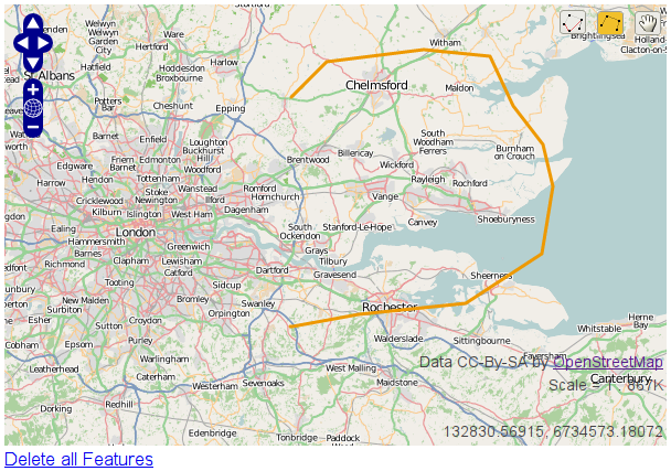
OpenStreetMap
# forms.py
import floppyforms as forms

class OsmLineStringWidget(forms.gis.BaseOsmWidget,
                          forms.gis.LineStringWidget):
    pass

class OsmForm(forms.Form):
    line = forms.gis.LineStringField(widget=OsmLineStringWidget)
Result:
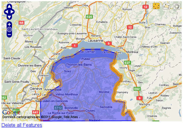
Google Maps
# forms.py
import floppyforms as forms

class GMapPolygonWidget(forms.gis.BaseGMapWidget,
                        forms.gis.PolygonWidget):
    google_maps_api_key = 'YOUR-GOOGLE-MAPS-API-KEY-HERE'

class GmapForm(forms.Form):
    poly = forms.gis.PolygonField(widget=GMapPolygonWidget)
Result: